
One man, 40 years of naysayers, and enough floodwater for half of Lake Michigan
 EASTERN WASHINGTON—Traveling from the verdant, mossy coastal belt of
the Pacific Northwest, one could be forgiven for feeling that the
defining characteristic of Eastern Washington is its dryness. It's a
land seemingly starved of rain in the shadow of the Cascade Mountains.
But the dry landscape known as the “Scablands” actually tells a story
about excess—excess of water, water that was torrential and sudden.
EASTERN WASHINGTON—Traveling from the verdant, mossy coastal belt of
the Pacific Northwest, one could be forgiven for feeling that the
defining characteristic of Eastern Washington is its dryness. It's a
land seemingly starved of rain in the shadow of the Cascade Mountains.
But the dry landscape known as the “Scablands” actually tells a story
about excess—excess of water, water that was torrential and sudden.The Scablands are essentially wounds, still unhealed by time and erosion. They cut through the land and down into the rock after a series of unfathomably large floods unleashed by the catastrophic draining of great glacial lakes—half the volume of Lake Michigan splashed onto the land in less than a week. If you can imagine that, you’ve got us beat. The story recorded in this landscape is so incredible, it took one geologist decades to convince his colleagues that he was reading it correctly.
Inflation of the modern American vernacular has devalued superlatives like “awesome” and “epic,” but we’re going to need them where we’re going.
Our protagonist
After growing up in Michigan, J Harlen Bretz (don’t ask—the J doesn’t stand for anything) was working as a high school biology teacher near Seattle around 1910 when the geology bug bit him. Hard. He and his wife Fanny (also a biologist) explored the land around them with a burning curiosity, and he began to produce pretty impressive maps and interpretations of the marks left on that landscape by glaciers.Bretz was keen on maps, eager to follow as the United States Geological Survey was mapping new areas of Washington. One of the results really caught his interest—it showed what appeared to be a pair of dry waterfall ledges high above the Columbia River in eastern Washington, with no source of water to be seen. Bretz couldn’t figure out what the hell they were doing there, and neither could any geologists he talked to. “Here was something that fascinated him as few things had before,” John Soennichsen wrote in his excellent biography Bretz’s Flood. Bretz couldn’t have known at the time that he just met the mystery that would become his legacy.
Before long, Bretz moved to the University of Chicago to get a PhD in geology. When he obtained it, he happily returned to the Pacific Northwest to teach at the University of Washington. It didn’t go well. His Socratic method of teaching and insistence on getting students into the field chafed his stodgy colleagues, whom he grew to despise.
And so, in 1914 the pendulum swung him back to the University of Chicago, where he would settle in. But even if Bretz couldn’t stand Washington’s geologists, he was still enamored with the state's geology. He began leading summer field courses to the Cascades and the Columbia River Gorge. There are plenty of odd things to notice about the gorge. One that caught Bretz’s eye was what geologists call “erratics”—boulders made of a rock type that can’t be found locally. Boulders are, it needn’t be said, rather heavy, so how do they travel great distances? The only transport they hitch a ride on is ice, and erratics are commonly strewn across glaciated landscapes. There was, however, no sign that glaciers had come far enough south to reach the gorge. So why the rocks?
One of these is not like the others
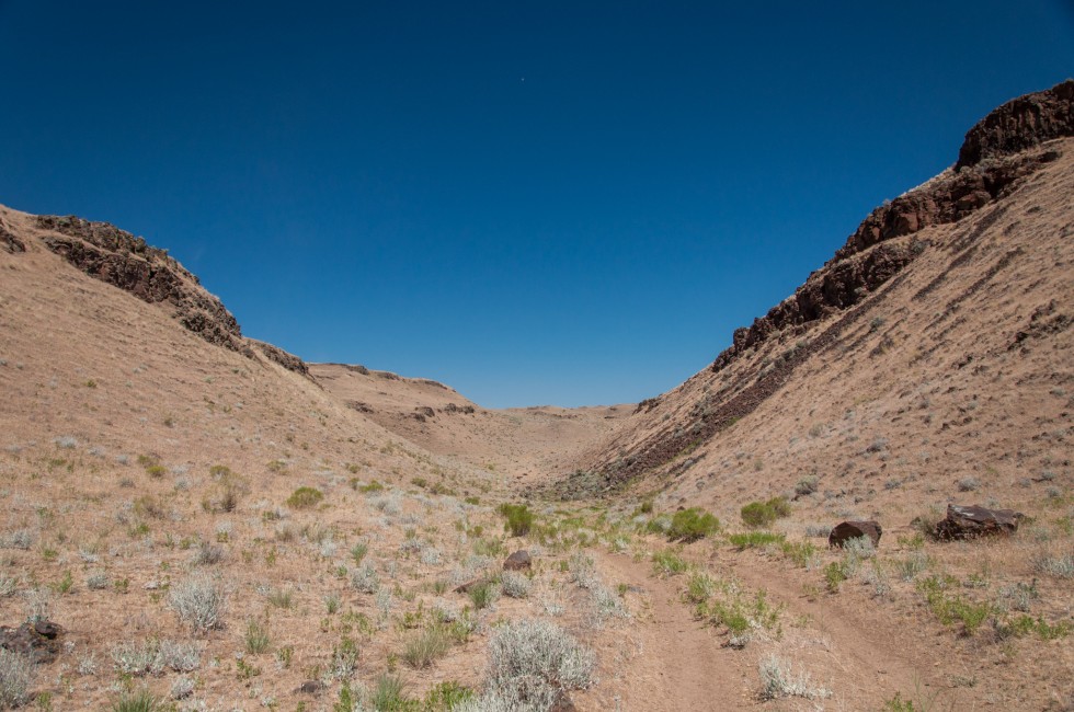
It’s hot (again), and I’m nearing the end of my four-day tour through the Scablands. I've come here to see the evidence of Bretz's great flood for myself. After I convince myself that I’m probably not about to wander onto private property, I scavenge batteries from a flashlight for my dead GPS unit, shoulder my pack, and point myself uphill. I’m at a place called Wallula Gap, just south of the “Tri-Cities” of Richland, Pasco, and Kennewick, where the Columbia River flows through a huge notch in the ridgeline of the Horse Heaven Hills.As I start down a sandy Jeep track, I’m only a few tens of feet above the river, but I’ll gain almost 800 feet before I reach the top. After a few minutes, the track turns away from the river, up into a steep-sided grassy little canyon. Cows have been here, as their footprints and gastrointestinal gifts can attest, as have humans messing around with shotguns. Thousands of years before them, coursing floodwater had been here, too. In fact, there wouldn't have been a “here” without it.
At the top, I look out over the dusty lowland. I try to picture it all underwater.
Soon, my GPS unit brings me to my target. I’ve come to see a rock. I’ve seen plenty of rock on my way up—black basalt layers from the massive volcanic eruptions that covered this entire region in floods of lava some 16 million years ago—but nothing like this one. The boulder is bright white, with small black mineral flecks and scattered lichen eking out a living on its surface. It is decidedly unbasaltish.


0 comments:
Post a Comment